


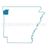
BOSTON Voting District, Washington County, Arkansas
About
Outline

Summary
| Unique Area Identifier | 528452 |
| Name | BOSTON Voting District |
| County | Washington County |
| State | Arkansas |
| Area (square miles) | 31.60 |
| Land Area (square miles) | 31.50 |
| Water Area (square miles) | 0.10 |
| % of Land Area | 99.69 |
| % of Water Area | 0.31 |
| Latitude of the Internal Point | 35.79344030 |
| Longtitude of the Internal Point | -94.39945720 |
Maps


Graphs
Select a template below for downloading or customizing gragh for BOSTON Voting District, Washington County, Arkansas


Neighbors
Neighoring Voting District (by Name) Neighboring Voting District on the Map
- CANE HILL Voting District, Washington County, AR
- Cove City Voting District, Crawford County, AR
- COVE CREEK Voting District, Washington County, AR
- Lee Creek Voting District, Crawford County, AR
- MORROW Voting District, Washington County, AR
- VINEYARD Voting District, Washington County, AR
Top 10 Neighboring County Subdivision (by Population) Neighboring County Subdivision on the Map
- Cane Hill township, Washington County, AR (1,530)
- Cove Creek township, Washington County, AR (715)
- Lees Creek township, Crawford County, AR (628)
- Morrow township, Washington County, AR (466)
- Boston township, Washington County, AR (392)
- Vineyard township, Washington County, AR (383)
- Cove City township, Crawford County, AR (219)
Top 10 Neighboring Unified School District (by Population) Neighboring Unified School District on the Map
- Prairie Grove School District, AR (9,100)
- Lincoln School District, AR (7,060)
- West Fork School District, AR (5,446)
- Cedarville School District, AR (5,220)